Vision: Healthy waterways and floodplains, managed for shared benefits
The Water theme focuses on surface and ground water resources, waterways (including wetlands) and floodplains. Water-dependent species, habitat values and management is considered. Refer Land theme or Irrigated Riverine Local Area regarding irrigation supply and systems and Biodiversity regarding threatened species.
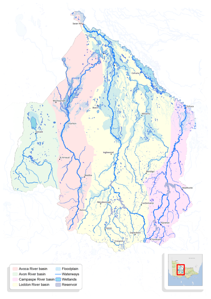
The North Central CMA region includes four inland river catchments, the Campaspe, Loddon, Avoca and Avon-Richardson, that rise on the northern slopes of the Great Dividing Range and flow northward emerging onto the wide, flat riverine plains of northern Victoria.
The catchments all form part of the Murray-Darling Basin, however average rainfall and streamflow is greater in the east of the region and declines across the basins moving from east to west. This influences the shape of the rivers and their floodplains, and the degree to which each river interacts with the mid-Murray River and its floodplain.
The region’s waterways, which include more than 100,000 km of streams and 1600 wetlands, have economic, environmental, cultural and social importance to Traditional Owners and regional communities.
Waterways and the plants and animals they support provide benefits to communities such as; water for drinking, irrigation and industry, as well as being a focal point for many recreation activities which in turn support tourism.
Victoria’s Water Plan, Water for Victoria, provides a framework to manage water for shared benefits – recognising social (including recreational), cultural, economic and environmental values. Our vision reflects this, to manage for shared benefits.
Waterways and water have significant value to Aboriginal people as recognised in Victoria’s Aboriginal Water Policy that was announced in Water for Victoria. The Traditional Owners engaged for this RCS identified many water-related cultural values and have strong aspirations for more involvement in water planning and management and for cultural flows. For more on this refer the Traditional Owner page.
There has been significant change to irrigated agriculture in the region, over the past 20 years, with water traded out of the region, and major upgrades to delivery infrastructure to improve efficiency. For more on this refer the Land theme and Irrigated Riverine Local Area pages.
Through engagement for RCS renewal we heard from many people in the region who are passionate about their local waterways. Residents and visitors enjoy walking, cycling, fishing, canoeing and camping in and around the region’s waterways, they are important for wellbeing, and for the livability of urban areas. Waterways are important habitat, supporting a diversity of wildlife, they function as drought refuges, and movement corridors. Landholders and community-based NRM groups, make a significant contribution to protecting and improving the health of waterways across the region.
However our region’s waterways are particularly vulnerable to hotter and drier conditions predicted with climate change. As our region’s population grows, there are increasing demands on surface and groundwater resources, including for urban water supply and a growing number of small farm dams and bores associated with rural residential developments. In drier landscapes like the Western Dryland Plains Local Area, some tensions between uses are evident, and with reduced water availability overall, we anticipate sharing benefits will become more challenging in the future. It will be important to work together to raise awareness of water resource constraints and make the most of every drop.
Assessment of current condition and trends
Waterways
Based on the most recent State-wide Index of Stream Condition assessment (2010), the majority of our regions waterways were in moderate or poor condition:
- 0% waterways in excellent condition
- 1% waterways in good condition (in Campaspe basin)
- 46% waterways classed as moderate, and
- 30% waterways in poor condition
- 21% waterways in very poor condition.
The impact of degraded ecosystems on aquatic plants and animals has been severe, both for species whose entire life history is within the region, but also for those who are only here for a short time.
For example, there has been a decline in waterbird populations across all feeding guilds by up to 90% since the 1980s across south-eastern Australia.
Of the 23 native fish species originally present in the region, only 18 species remain, and of those, eight species are listed as threatened under national and/or state legislation.
Climate change is a major threat to the region’s waterways, wetlands and water resources. For example, in the past 20 to 30 years, there has been reduced average rainfall, with all river basins experiencing a significant decrease in average annual streamflow since the 1980s and 90s.
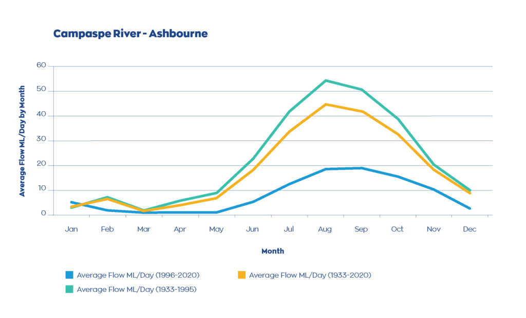
This graph compares the long-term stream flow data to records from 1996 (average daily stream flow by month) at one site in the headwaters of the Campaspe River at Ashbourne – demonstrating a significant decline in stream flow over the past 25 years.
The ‘Victoria’s Water in a Changing Climate, Insights from the Victorian Water and Climate Initiative‘ study found that the relationship between rainfall and run-off (which translates into streamflow) had changed significantly for many catchments during the Millennium Drought, meaning that a reduced proportion of rainfall is reaching our waterways. Eight years later, more than one-third of the catchments studied, including those in the north central region, show no signs of recovery. This clearly demonstrates the current and future vulnerability of water resources in our region in response to dry conditions and droughts.
Wetlands
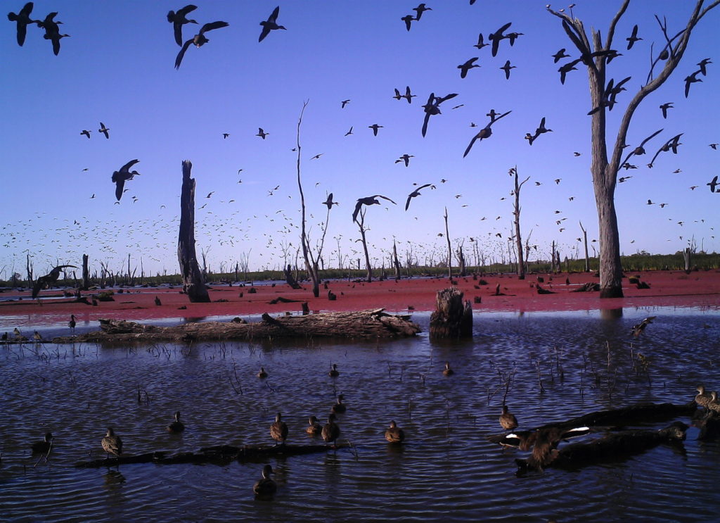
The north central region includes some significant wetlands, including the internationally recognised (Ramsar listed) Kerang and Gunbower Forest wetlands. Wetlands in the region are generally rated in moderate condition although only a limited number of high priority wetlands have been assessed based on the Index of Wetland Condition.
For example:
- 16 wetlands assessed within the Ramsar listed Kerang Wetlands are in moderate condition with two in poor condition.
- In Gunbower forest, 50% of plots assessed were in good condition, 30% in moderate condition and 10% in poor condition.
The Living Murray program, funded by Basin States and the Commonwealth and coordinated by the MDBA, focuses on maintaining the health of six icon sites along the Murray River, including the Gunbower-Koondrook-Perricoota Forest site. The Victorian part of this site is within the north central region. The program involves, engineering works to facilitate the efficient delivery of water for the environment to protect and enhance environmental and cultural values, and a long-term ecological monitoring program which is useful to understand the condition of this site.
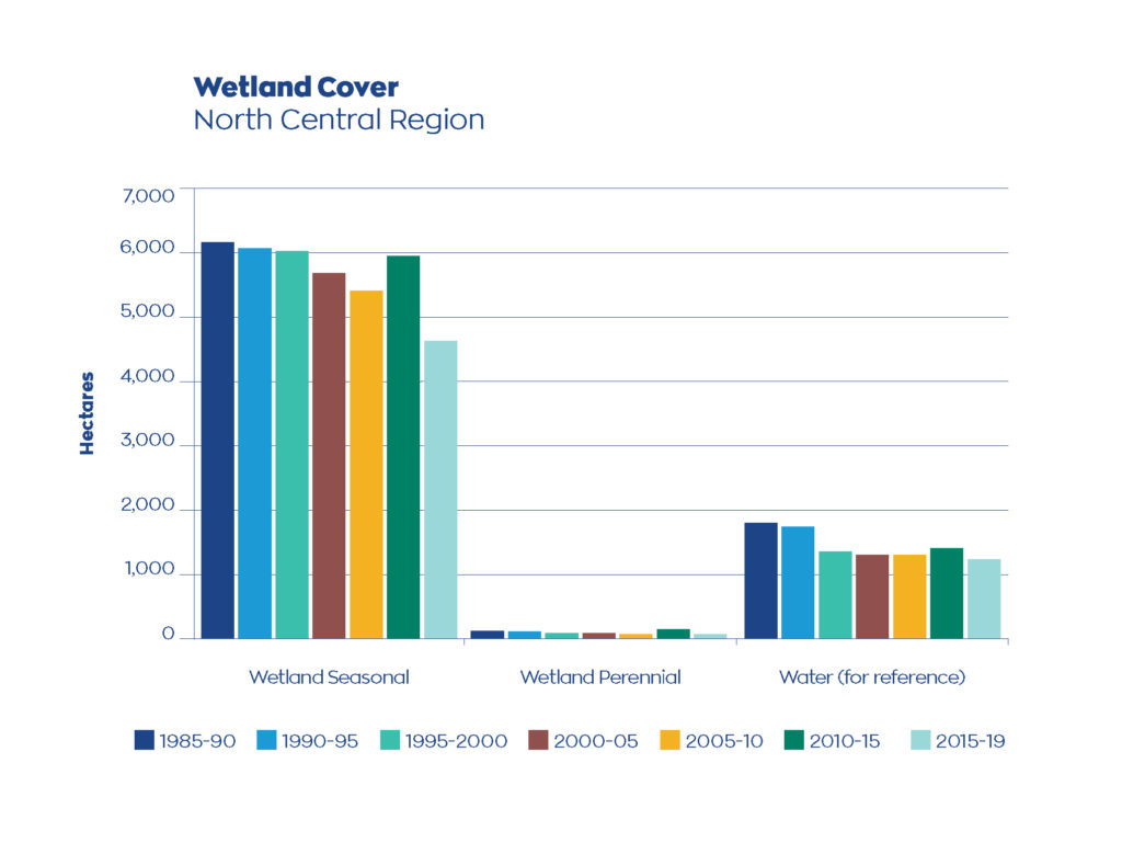
The Victorian Land Cover Time Series 1985-2019 shows trends over time for different land cover classes, including wetlands. This will enable us to track changes in wetlands and associated vegetation cover across public and private land over time. As shown in the graph here, both perennial and seasonal wetland extent decreased between the first and last epoch. Whilst improved protection and management of wetlands, including the delivery of environmental water, can influence the extent of wetlands, rainfall has a big influence.
Floodplains
More than 780,000 ha of rural and urban land across the region, under both public and private ownership, are subject to inundation by a 1% Annual Exceedance Probability flood (1–in-100-year average recurrence interval). River regulation works and inappropriate development in the past, have had a significant impact on the natural floodplains by changing the flood frequency and flooding patterns, causing deterioration in the natural riverine, floodplain and wetland environments. Often, natural wetlands can remain dry (or at least not fill) in a flood because natural flood runners have been modified or the delivery infrastructure to direct flows is limited.
Groundwater
Regional groundwater systems are for the most part, ancient river gravels that lie buried below the floodplains of the river systems and their tributaries, extending from the upland valleys of the region, out into the Riverine Plains. Groundwater within most local and sub-regional flow systems in the region is saline, particularly in those areas where the annual rainfall is below 600 mm. Sub-regional aquifer systems within the Loddon and Campaspe catchments are an exception, as they are known to contain useful quantities of lower salinity groundwater commonly used for stock and domestic purposes or for irrigation (e.g. potato industry in the upper Loddon River basin around Smeaton). Lower salinity groundwater also features in the mineral water industry in both the upper Campaspe and Loddon catchments, and is well known from the Daylesford and Hepburn Springs areas.
Groundwater in the larger freshwater aquifers is extensively used for irrigation, with trading and allocations managed by rural water authorities. A drying climate means less groundwater recharge (replenishment) and recession of groundwater levels has been observed across most aquifers. Whilst this recession is not yet severely impacting availability for all irrigators, it is nevertheless a longer-term concern, and coupled with a trend of increasing groundwater use across the region, will need to be closely monitored. Several of the more extensively used systems, such as the Lower Campaspe Valley Water Supply Protection Area (WSPA), the Loddon Highlands WSPA and the Mid-Loddon Groundwater Management Area (GMA) are showing trends of decreasing recovery over time. Irrigator access to groundwater entitlements in the Lower Campaspe Valley have been limited to 75 per cent since 2019-20.
Groundwater level trends for WSPAs and GMAs in the north central region (from Victorian Water Accounts reports).
| Groundwater level trends (June) | Lower Campaspe Valley WSPA | Loddon Highlands WSPA | Central Victorian Mineral Springs GMA | Mid Loddon GMA |
| 2014 | Rising | Rising | (no data) | Rising |
| 2015 | Stable | Rising | (no data) | Rising |
| 2016 | Declining | Declining | (no data) | Declining |
| 2017 | Declining | Declining | Stable | Declining |
| 2018 | Declining | Declining | Stable | Declining |
| 2019 | Declining | Declining | Stable | Declining |
Improvements in condition
Implementation of the RCS, and the North Central Waterway Strategy by the North Central CMA, partner organisations and community groups, has seen significant investment in management interventions over the past 10 years. The North Central CMA and program partners undertake monitoring, evaluation, reporting and improvement (MERI) activities as part of all NRM programs and projects that, while unable to determine the condition of entire river systems or wetland complexes, have demonstrated improvements in condition where works have occurred. For example:
- Improved conditions for native fish such as silver and golden perch and Murray cod and improved riparian conditions on the Campaspe River through the Caring for Campaspe and Water for Environment program.
- The Waterwatch program has shown how citizen science can be used to demonstrate outcomes. For example, Waterwatch has measured an increase in diversity and abundance of macroinvertebrates on sites where woody habitat has been reinstalled in the Pyramid Creek.
- The benefits of riparian works including for example; exclusion of stock, pest plant and animal control, and revegetation (as shown in the photos below) are well established.
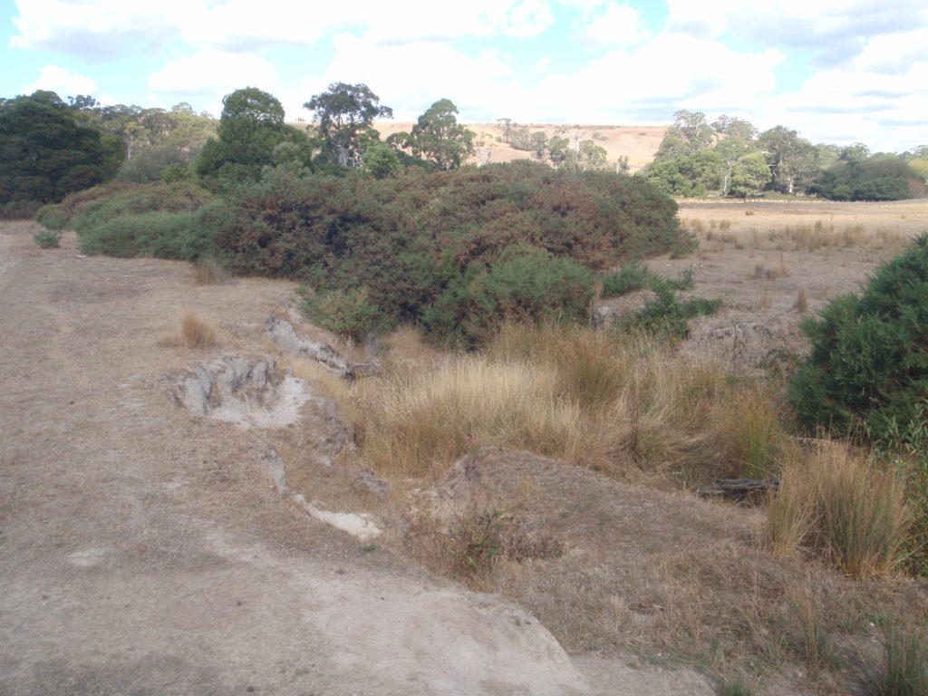
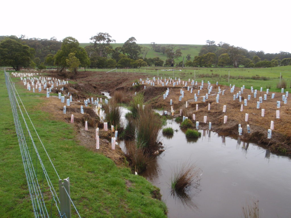
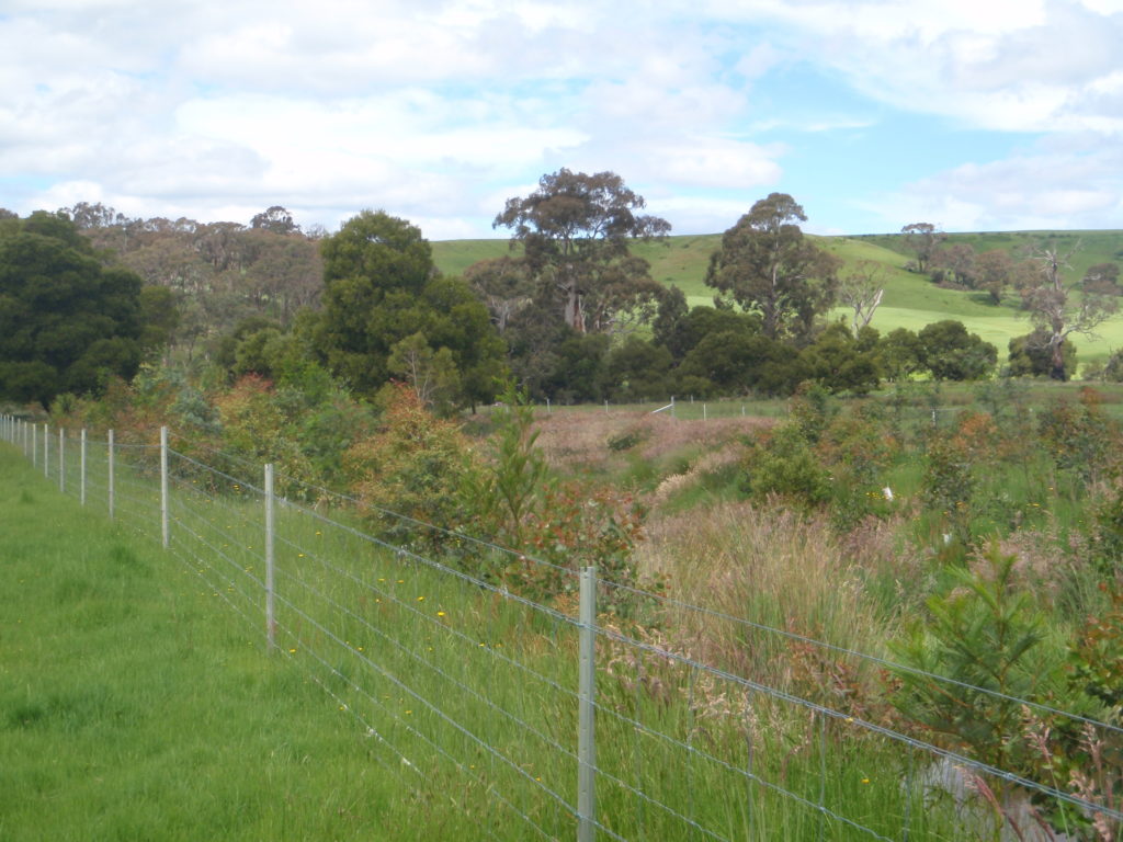
Riparian works to exclude stock and revegetate
Riparian works undertaken by the North Central CMA will be used to track progress of our efforts to protect or improve the condition of riparian land and track progress towards related targets (refer outcomes below).
Major threats and drivers of change
Our changing climate
Climate change is the major threat to our region’s waterways, putting pressure on water resources and exacerbating existing threats. Key climate change projections for the region include; increased temperatures, reduced rainfall over the cooler months, and increased frequency of extreme weather events.
Surface and groundwater resources are under pressure from population growth in some areas. The ‘Victoria’s Water in a Changing Climate, Insights from the Victorian Water and Climate Initiative‘ study clearly demonstrates the current and future vulnerability of water resources in our region in response to dry conditions and droughts. This must be accounted for in water resource and climate change adaptation planning for our waterways and wetlands.
Reduced streamflow has adverse impacts on water quality and instream habitat. Waterways that are predicted to be more vulnerable to climate change, are the unregulated waterways including the upper reaches of the Loddon and Campaspe Rivers and the Avoca and Avon-Richardson catchments. Existing threats to waterways including erosion and sedimentation are likely to be exacerbated by increased frequency of intense rainfall events, so erosion control, including exclusion of stock and revegetation of riparian zones will continue to be important. Water quality in water storages will also be affected by increased temperatures and low flow conditions, particularly in summer and autumn, increasing the risk of blue-green algal blooms containing toxins that are harmful to humans and animals.
For wetlands, the timing of wetting and drying cycles is likely to change significantly and combined with increased temperatures and evapotranspiration this may lead to permanent and irreversible changes in wetland structure and function. Some wetlands are more vulnerable than others because they are sensitive to the key climate stressors. The source of water is an important factor, with floodplain wetlands that have tenuous connections to major rivers (e.g. Kamarooka wetlands complex), or wetlands that fill solely from surface run-off such as the (e.g. Moolort Plains wetlands) being particularly vulnerable to dry conditions. Refer mapping in the North Central Climate Change Adaptation and Mitigation Plan for other vulnerable wetland systems.
Flooding is a natural hazard and the region is threatened both from the reduced frequency and duration of minor to moderate floods that are essential for many ecological and cultural values across the landscape, and also from the social and economic impacts when major to extreme flooding occurs. The North Central Regional Floodplain Management Strategy identifies actions that will improve the flood resilience of our communities and facilitate quicker recoveries by individuals and businesses, reducing the social and economic impacts of future flood events. Making the most of available water will be increasingly important in the hotter, drier climate predicted with climate change, and this includes floodwaters. Restoring natural flows across areas of the floodplain, can have both land health and ecological benefits, and this has been identified as a priority for investigation in this RCS.
Groundwater recession is expected to worsen with climate change, so managing increasing demand in this context will be a challenge. This not only a concern for irrigators, but it also threatens ecosystems that are dependent on shallow groundwater systems, including ephemeral soaks that support unique flora and fauna. Knowledge of the water balance in these areas is still developing. There is an ongoing need to manage salinity issues generated by the discharge of saline groundwater, particularly within the irrigated lands of northern Victoria. Recent applications to use saline groundwater for irrigation in this area have raised concerns, particularly for the longer-term viability of soils irrigated with high salinity water. Domestic and stock access remains an issue, as licences are only required for bore construction, but not use. The proliferation of domestic and stock bores without licences only increases the pressure on aquifer systems.
Population growth
Greater Bendigo is among the fastest growing regional Local Government Areas in Victoria, with a projected 1.6% increase in population between 2018-36, which equates to an additional 37,700 people. In the south-east of the region accessibility, affordability (compared to Melbourne) and amenity values are driving strong population growth. This growth puts increasing demands on urban water supply. There is also strong growth in rural residential developments, which typically include small dams or bores, which puts added pressure on surface and groundwater resources in these important water supply catchments.
Other threats and impacts
The list below describes other threats and impacts to waterways, noting that some are the result of past land use or management and some are ongoing.
| Threats | Impacts |
| Legacy of extensive land clearing. Present day clearing or over grazing of riparian areas and wetlands. Recreational practices that cause erosion or contamination of waterways. | Run-off from exposed soils, with erosion exacerbated by dry spells and extreme weather events, increase sediment and contaminant loads (also direct contamination) impacting water quality and instream habitat. Reduced input of organic matter and structural woody habitat to rivers leading to limited food availability and impacting habitat available for biota to complete critical life stages. |
| Waterway regulation, water extraction, altered flow regime in rivers and wetlands. | Loss of biological cues for aquatic species, reduced linkages, changes to habitat availability and changed geomorphic processes. |
| Removal of structural woody habitat in waterways. | Loss of habitat for aquatic biota to complete critical life stages |
| Clearing, grazing, drainage and laser grading of wetlands. | Reduced extent or loss of wetlands. |
| Pest plant and animals. | Predation of native species, outcompete native species Reduced regeneration of native vegetation. |
| Cold water releases from the depths of large water reservoirs (e.g. Eppalock). | Causes water temperature change, impacting critical life stages for many native fish species. |
| In-stream barriers, levees and other infrastructure that restrict connectivity. | Reduction or loss of floodplain linkages and disrupted linkages to waterways reduces habitat, and restricts species movement between systems in response to changing conditions. |
| Blackwater occurs when organic material is washed into waterways. When the weather isn’t too hot and the water is flowing, this nutrient-rich water is good for the ecosystem. But when the weather is hot, a summer storm hits, and the water is not moving, too much oxygen is used up trying to break it down. | Insufficient oxygen in the water for fish and waterbugs, and if they can’t move to a safer spot in the river with more oxygen, they can die. |
Opportunities
There are many opportunities at local and regional levels to support restoration and improve waterway health. A key to realising these opportunities is to ensure that RCS partners, Traditional Owners and community are working together to address the threats facing our waterways.
Climate change will continue to be a key threat to the region’s waterways and water resources. Our efforts to protect and improve riparian zones and wetlands, to exclude stock and revegetate, have many benefits including to improve climate resilience. Revegetation helps prevent erosion and filter contaminants, while shading helps lower the water temperature and reduce evaporation. Protection of drought refuges, e.g. shading of deep pools where water persists in dry periods, will be a priority.
Delivery of water for the environment in systems where this is possible, and when the water is available, can offset the impacts of climate variability to a degree. By understanding what patterns are likely to be in the future, some resilience can be built into the systems. Then over time, the system can be managed to adjust to longer-term changes to flows. For some waterways and wetlands, adaptation options may be limited, and in the long-term a transition to a more terrestrial system is likely.
Local government has an important role to play in protecting local waterways, as public land manager, through planning controls, and engagement with community to build awareness. Many volunteers and local community groups are actively involved in caring for local waterways, for more on this contribution refer the Community theme page. Urban waterways are important for recreation and wellbeing, the Integrated Water Management Framework for Victoria is designed to help regional stakeholders to work together, ensuring the water cycle contributes to the liveability of Victoria’s towns and cities. To facilitate this, Integrated Water Management forums have been established in the region, to identify, prioritise and oversee the implementation of projects, to implement Water Sensitive Urban Design (WSUD) principles.
With reduced water availability we must also continue our efforts to improve the efficiency of irrigation systems (see Land theme page). Building community awareness and capacity around the management of water resources and waterways, in the context of climate change will be important. There are also opportunities to maximise the potential of available water. As with the Native Fish Recovery Plan, where ecological outcomes are being achieved within a highly regulated waterway system by embedding fish restoration flows into irrigation flows – that is using every drop twice, once to assist native fish and again to meet consumptive uses. Further opportunities are being investigated, to restore natural flows across parts of the floodplain for ecological and land health benefits.
Over the past 10 years large-scale integrated waterway restoration projects like Caring for the Campaspe have shown that concentrated effort can improve riparian and in stream conditions. Development pressure, particularly in the south east of the region and within water supply catchments, is putting pressure on water resources and threatening the health of our waterways too. Projects like A Healthy Coliban Catchment take a collaborative and integrated approach which includes updates to planning controls, works to protect and improve the health of the catchment and water quality, backed up with a long-term monitoring program including citizen scientists.
It is important that we continue to collaborate to deliver successful integrated catchment management projects, and support the efforts of local communities to care for their local waterways. The region’s waterways hold a special place for the region’s Traditional Owners. Supporting the Traditional Owners right to self-determination and their specific aspirations around water and waterways will be important focus for government partners.
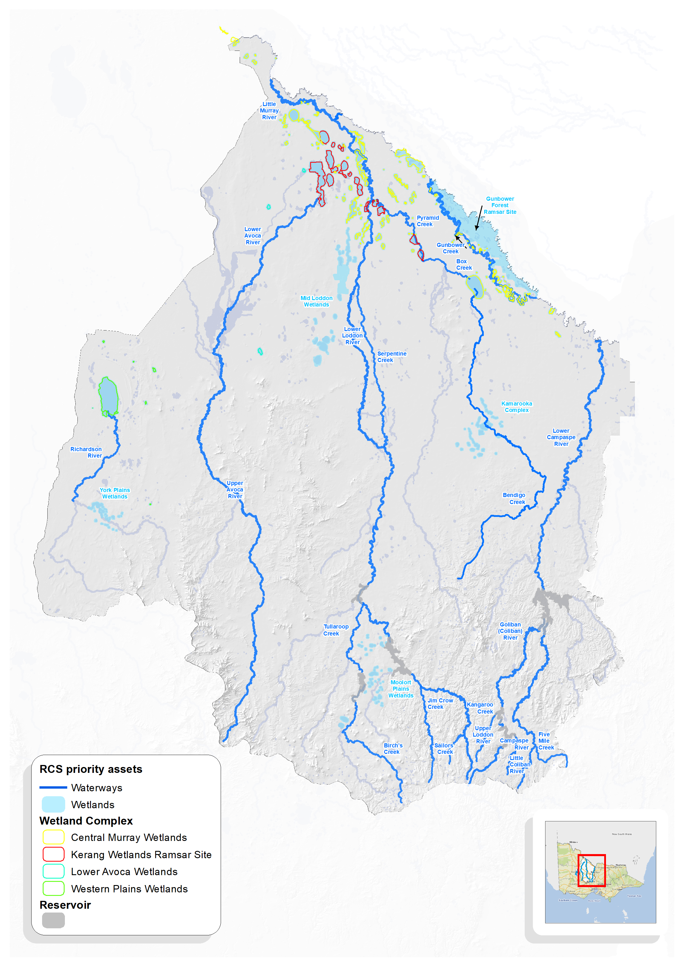
Priority assets
The North Central RCS takes an asset-based approach, identifying the region’s highest priority natural assets (waterways, wetlands and biodiversity) to focus our efforts and investment on protecting and enhancing those assets with the most significant values, that are under the greatest threat, and with the highest likelihood and feasibility of protection and enhancement.
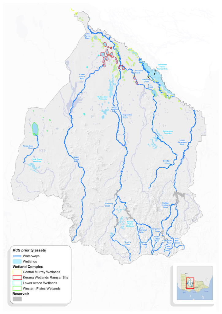
The RCS priority waterway and wetland assets were first identified as part of 2013-19 RCS development (refer Strategy Development for more detail). Further assets were identified as part of North Central Waterway Strategy 2014-22 development. This priority setting was based on a rigorous process in which community and partners identified assets that were assessed considering; environmental significance, threat to asset, feasibility of action, technical and socio-economic risks.
For RCS renewal, new knowledge, policy and strategy were considered. The proposed priority water assets for RCS 2021-27 as shown on the map include:
- All 2013-19 RCS waterway and wetland assets
- Additional waterway and wetland assets from the North Central Waterway Strategy 2014-22
- Additional assets identified through engagement, considered significant due to new knowledge or policy.
Through RCS renewal engagement process there were some places identified as important by the community that have not been included as priority assets. This does not diminish the value of these places. Engaged and active communities who care for their local environment are an asset in themselves, and different funding streams (e.g. Landcare grants) can be leveraged for locally important assets. It is acknowledged that the health of tributaries is linked to the health of priority waterways. A more detailed review of waterway assets is anticipated for the upcoming renewal of the Regional Waterway Strategy in 2022-23.
Priority directions
Priority directions and outcomes were developed to respond to the challenges and opportunities identified, and to align with the state-wide RCS Outcomes Framework. We engaged key government partners to confirm delivery roles and improve accountability for RCS implementation. The organisations identified as ‘key collaborators’ in the tables below, will be involved in initiating (including to source investment), but in order to succeed, partnerships, participation and support of many others is needed, including;
- Rural landholders, associated community-based NRM groups, volunteers and the broader community.
- Non-government organisations, industry and research organisations.
- Traditional Owners to speak for Country and participate/partner/lead (self-determination) in the delivery of RCS directions and outcomes.
| Priority Directions | Key Collaborators |
| Continue to build partnerships with Traditional Owners towards self-determined participation and leadership in water planning and management. | Traditional Owners and RCS partners |
| Collaborate to: – improve our understanding of the predicted impacts of climate change on water resources and aquatic ecosystems in the region – consider related impacts and scenarios in strategic and operational planning – prioritise and implement urgent climate change mitigation and adaptation strategies. | CMA, Water Corporations, DELWP, Parks Vic |
| Improve current monitoring and analysis of water resources and waterways to detect long-term changes and trends due to climate change and enable timely adaptation. | CMA, DELWP, Water Corporations |
| Build community awareness and capacity around the management of water resources and waterways, in the context of climate change. | CMA, DELWP, VEWH, Water Corporations |
| Continue to support the collaborative development and implementation of Integrated Catchment Management projects. | CMA, Water Corporations, public land managers |
| Continue to collaborate to implement integrated water solutions in urban areas by applying Water Sensitive Urban Design principles. | Urban Water Corporations, Local Governments, CMA |
| Within the floodplain, identify locations where natural flows could be restored across and retained within the landscape, to improve connectivity, to increase waterbird habitat and for land health benefits, implementing pilot projects to trial and expand this practice. | CMA, GMW |
| Avoid, reduce and manage flood risk to community, through continued implementation of the North Central Regional Floodplain Management Strategy 2018-28. | CMA, LGs, SES |
| Seek to continue socio-economic monitoring of environmental watering, to contribute to a more holistic understanding of outcomes. | CMA, VEWH, Parks Vic |
| Continue to apply an integrated approach to the planning and delivery of water for the environment, undertaking complementary works and where possible using consumptive water, to achieve landscape scale outcomes. | CMA, VEWH, DELWP, Parks Vic, Water Corporations |
| Maintain and improve the health of priority waterways through continued implementation of the North Central Waterway Strategy 2014-22, renewing this strategy by 2023. | CMA |
| Continue to implement Flagship Waterway projects including the mid-Murray Native Fish Recovery project. | CMA |
| Investigate environmental watering of other potential wetlands in the Wimmera Mallee pipeline area. | CMA |
| Investigate opportunities to reconnect Avon Plains wetlands to increase natural flow conditions. | CMA |
Outcomes
| Long-term SMART outcomes | Key Collaborators |
| Improved condition of RCS priority waterways (rivers and wetlands), by 2041 | CMA |
| Improved floodplain connectivity for ecological function, considering social and economic risks to communities, by 2041 | CMA |
| Medium-term SMART outcomes | Key Collaborators |
| Increase the extent of protected or improved riparian land, on priority RCS waterway assets, by 850km, by 2027 | CMA, DELWP |
| Improved stream connectivity by 240km and improved instream habitat by 100km, by 2027 | CMA, GMW |
| Increased protection and improved management of 20,000 ha of priority RCS wetland assets, by 2027 | CMA, DELWP, Parks Vic, Rural Water Corporations |
| Deliver on 95% the environmental watering actions at planned sites based on annual Seasonal Water Plans, by 2027. | VEWH, Water Corporations |
The RCS Water Discussion Paper was drafted to frame conversations with stakeholders, obtain feedback and inform the development of this webpage. It includes more detail and references.