Introduction
The Northern Dryland Plains includes the traditional lands of the Dja Dja Wurrung (west of the Campaspe River), Taungurung (east of the Campaspe River) and Barapa Barapa (north of Mitiamo) peoples.
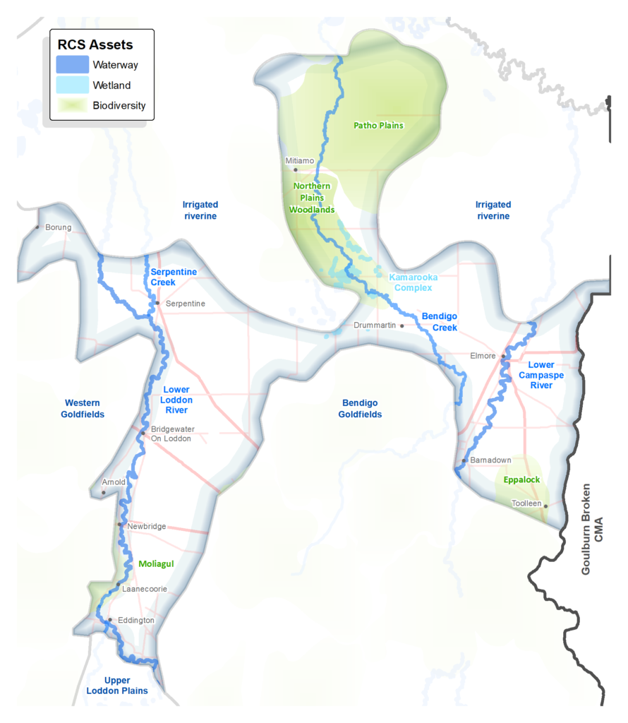
The area is located on the riverine plains to the north and west of Bendigo, and is largely agricultural, with dryland cropping the dominant land use. It is generally within commuting distance of regional centres (Bendigo, Echuca), which is what distinguishes it from the cropping areas further west.
The lower Loddon and Campaspe Rivers and Bendigo Creek run through the area. The landscape is largely cleared for farming, and there is a relatively low proportion of native vegetation, though it does include most of the Patho Plains biodiversity asset (including Terrick Terrick National Park), which comprise native grasslands that are critical habitat for the Plains-wanderer (refer Biodiversity theme page for more). There are concerns regarding the ongoing loss of threatened native grasslands in this area due to change of land use (grazing to cropping).
A snapshot
| Aspect | Description |
| Key partners | Traditional Owners: Dja Dja Wurrung, Taungurung, Barapa Barapa DELWP, Parks Victoria, Trust for Nature and Agriculture Victoria. Local Government: Campaspe and Loddon shires, City of Greater Bendigo Landcare Networks: Campaspe, Loddon Plains, Mid Loddon, Connecting Country. Water corporations: Goulburn Murray Water (rural), Coliban Water (urban). |
| Socio-economic | Moderate socio-economic advantage overall. |
| Bioregion | Victorian Riverina Northern Inland Slopes |
| Native vegetation cover | There is a relatively small percentage of native vegetation. The Land Cover Time Series data for the period 2015-19 showed that native vegetation of some type covered just 18% of this area. |
| Rural residential or agricultural | Mostly agricultural – as interpreted from ABS data. |
| Agricultural land use | Predominantly dryland cropping, with some irrigated areas along the Loddon and Campaspe Rivers. The Land Cover Time Series data for the period 2015-19 showed that dryland cropping covered 72% of this area. |
| Soils and land use overview | The Northern Dryland Plains, at the southernmost extent of the vast Riverine Plains, comprise red and grey clay soils extensively used for cereal cropping. Subsoils soils are intrinsically sodic and, accordingly, need to be managed very carefully to avoid both wind and water erosion issues that stem from the loss of soil structure in response to dispersion promoted by a lack of ground cover and/or excessive cultivation. Sustaining soil structure and building suitable levels of soil organic carbon within an intensive cropping regime continues to be problematic although progress has been made through the widespread adoption of conservation tillage and more recently the growing of cover crops. The Riverine Plains are interrupted in the north by the Terrick Ranges north of Mitiamo. This is a granitic intrusion that for the most part remains parkland under native vegetation. East of the ranges lies the Patho Plains, and the floodplain of the Bendigo Creek. In common with the plains further south and west the Patho Plains are prone to issues with soil structure and perhaps to an even greater extent given the fine-grained nature of the sediments consistent with lower catchment distal deposition. |
Current and future challenges
The Northern Dryland Plains continues to face many challenges including:
- The increasing mechanisation of cropping reduces labour requirements and increases farm sizes (through amalgamation) which leads to a declining population and volunteer base. However, because of the proximity to off-farm employment in Bendigo and Echuca, there is less pressure for farm aggregation in the Northern Dryland Plains area (as compared to the Western Dryland Plains) and the main towns have not experienced population decline.
- Climate change will continue to place pressure on farmers , with drier conditions and more frequent extreme weather events predicted. Maintaining groundcover to reduce erosion and community-based planning and adaptation will be important.
- Intensification of land use (e.g. grazing to cropping) is a serious concern for threatened native grasslands and the critically endangered Plains-wanderer in this area.
Opportunities
Key opportunities for the Northern Dryland Plains include:
- Participatory approaches where farmers work together on common challenges and solutions, including to better understand the future impacts of climate change, explore future scenarios and consider possible long term adaptation options.
- Improved retention of native vegetation including threatened native grasslands.
- Solar farm developments in this area, further supported by the proposed Kerang Link transmission upgrade, present an opportunity to work with developers to contribute to local biodiversity and other RCS outcomes.
Priority directions and outcomes
Priority Directions and Outcomes are covered in more detail under each Theme. The following are particularly relevant to the Northern Dryland Plains:
- Continue to build partnerships with Traditional Owners towards self-determined participation and leadership in water and biodiversity planning and management.
- Deliver community-based participatory programs that build the capacity of land managers to improve land health.
- Work together to develop place-based climate change resources for land managers to inform adaptation.
- Build community awareness and capacity around the management of water resources and waterways, in the context of climate change.
- Improve the retention and restoration of native vegetation and habitat on private land through; community education and community-based programs that support stewardship and permanent protection, leveraging government and market-based incentives.
- Collaborate to increase awareness of legal requirements for the protection of native vegetation and habitat and improve compliance.
Outcomes (region-wide targets):
- Maintain an annual average percentage of no more than 20% exposed soils across the region, increasing area protected from wind and water erosion over the dry seasons, by 2027.
Priority directions relevant to the regional community generally include:
- Build capacity, networks and leadership to enable community led climate solutions for land, water and biodiversity management.
- Support, improve and expand the environmental volunteering sector, including Landcare, to enable adaptation to demographic shifts, to continue their important role in NRM.
- Enable, improve and promote opportunities for people to connect with nature, in both urban and rural settings, for wellbeing, to build awareness and appreciation, and inspire action.
- Support schools and young people to participate in programs that increase their knowledge and awareness of natural resource management.
- Continue to support integrated citizen science programs that engage community and provide useful targeted data to inform water, land, climate and biodiversity programs.
.