The RCS Local Areas characterise the diversity of the region and provide a basis for integration of RCS themes in a way that is relevant to local communities. Our local areas were defined based on the following criteria:
- Predominantly agricultural or rural residential.
- Proximity to regional centres for employment.
- Dominant agricultural land use.
Each of the Local Areas have unique sets of threats to land, water and biodiversity and/or challenges for farmers/rural landholders and by extension their communities.
A summary of the RCS Local Areas and how they were defined is outlined below. Characteristics of each area are described in more detail, and priority directions and outcomes of particular relevance are highlighted, on the pages for each area. You can access those pages by clicking on the labels on the map here.
Irrigated area
- Irrigated Riverine – defined by Goulburn Murray Irrigation District (GMID) within region, irrigated but many transitioning to dryland agriculture, water availability is biggest driver, includes significant wetlands.
Dryland – predominantly agricultural
- Western Dryland Plains – mostly full-time farmers, dryland cropping, remote from regional centres.
- Northern Dryland Plains – mostly full-time farmers, dryland cropping, not too far from regional centres.
Dryland – mixture agricultural and rural residential
- Western Goldfields – high proportion of rural residential between Talbot and Wedderburn but not well connected to regional centres for employment, cropping on the Natte Yallock plains and grazing elsewhere, relatively high proportion of remnant native vegetation.
- Upper Loddon Plains – some rural residential areas but mostly agricultural, productive soils with a mixture of dryland grazing and cropping not too far from regional centres low proportion native vegetation.
Dryland – rural residential areas
- Southern Uplands and Bendigo Goldfields – within commuting distance to Melbourne, Ballarat or Bendigo; high proportion and growth in rural residential properties; relatively high proportion of remnant native vegetation, otherwise mostly grazing.

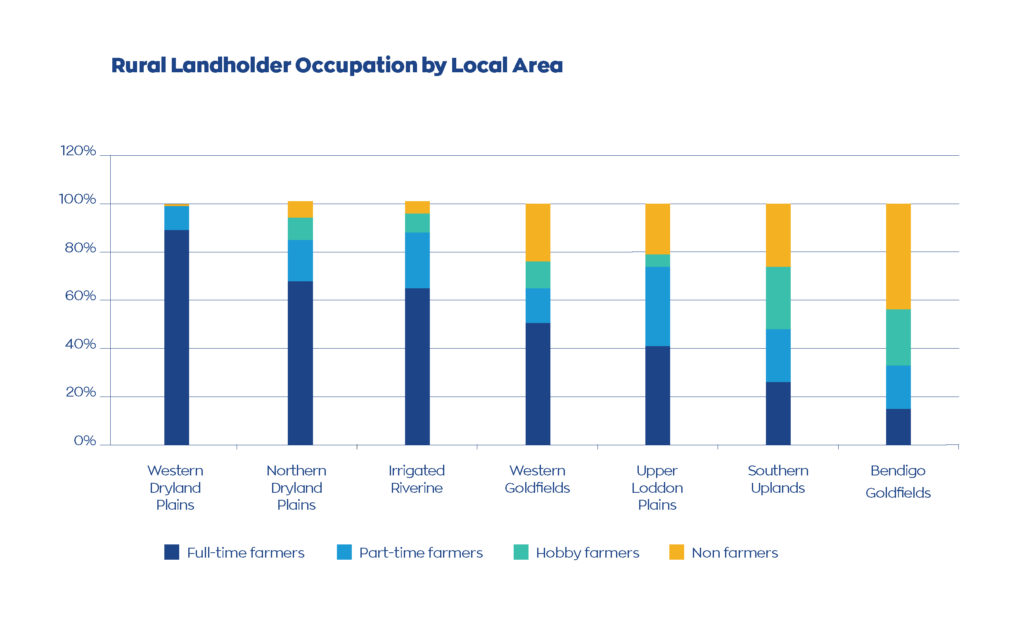
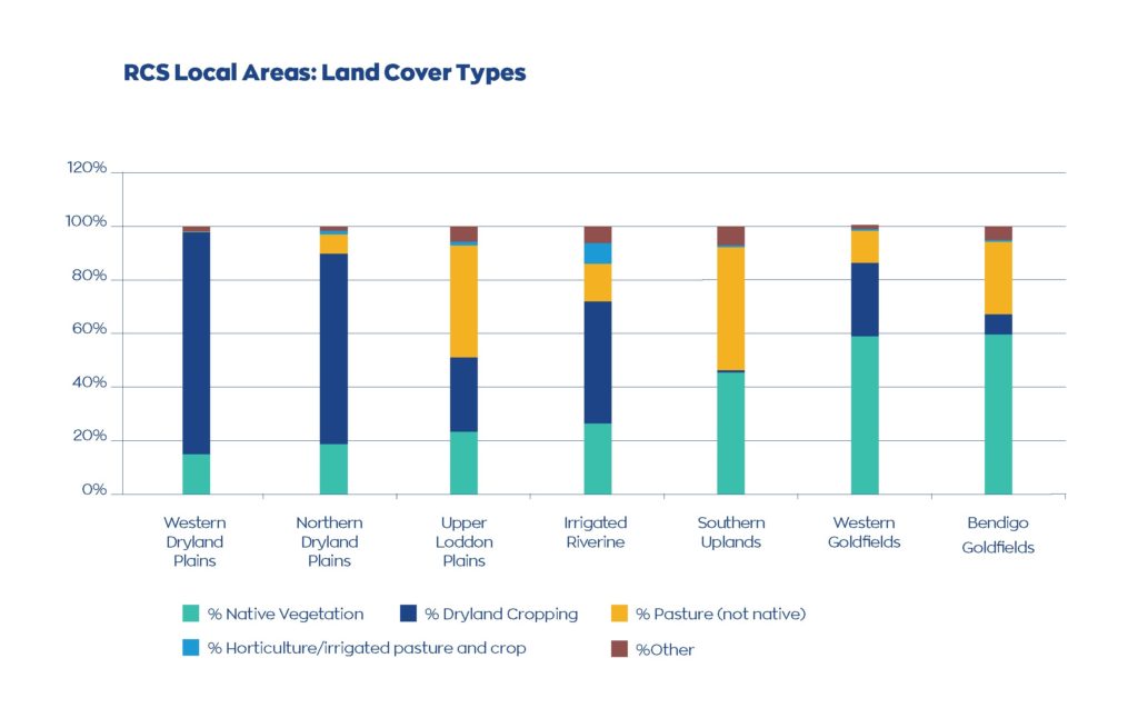
Engagement for RCS renewal has informed our understanding of RCS Local Areas, together with an analysis of ABS data, Victoria’s Land Cover Time Series, and the results of a large survey of rural landholders (properties > 10 ha.) across the region. This survey was undertaken in 2014 and repeated in 2019, to better understand the demographics, values and beliefs of the regional community. Both surveys found significant differences between responses from Full-time farmers, Part-time farmers, Hobby farmers and Non-farmers. The 2014 and 2019 survey reports describe the methodology, and present responses by landholder type and Local Government Area. The survey results were then cut by RCS Local Area, which is presented in another report – see link below.
These reports provide useful insights regarding rural landholders in the region, highlighting significant differences between landholder types, Local Government Areas and RCS Local Areas. Some of the significant differences between RCS Local Areas, including proportion of full-time farmers, native vegetation cover and agricultural land use are shown in the graphs below.