Introduction
The Irrigated Riverine area includes the traditional lands of the Dja Dja Wurrung people (southern parts), then along the Murray River from east to west; Yorta Yorta, Barapa Barapa, Wamba Wemba and Wadi Wadi peoples.
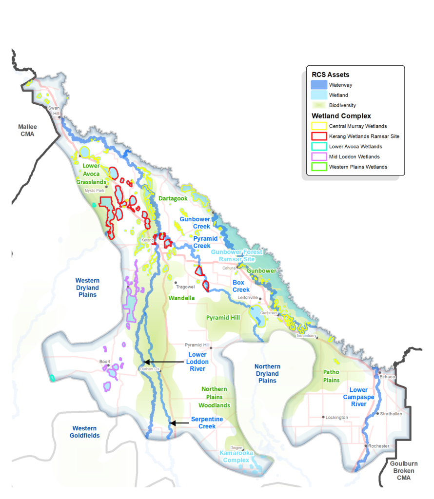
The area includes the floodplains of the Campaspe, Loddon and Avoca River catchments, encompassing a complex system of waterways and many wetlands. Development of irrigation infrastructure and flood levees have altered the natural connectivity between waterways in this landscape.
This is the northern fringe of the north central region and defined by the extent of irrigation infrastructure in the GMID area. Since the 1990’s when irrigation use was at its peak, there have been significant changes leading to a reduction in irrigation and land use change, which is continuing today. Many farmers have or are transitioning to dryland agriculture or only irrigate opportunistically.
Echuca is a popular tourist destination and there are many other attractions along the Murray River valued by locals and visitors including; the Murray River Adventure Trail, wharf precincts, and Gunbower National Park and other reserves.
Despite being predominantly agricultural, the area has high environmental and cultural significance including internationally recognised Ramsar wetlands (Kerang Wetlands and Gunbower Forest) and is habitat for many migratory water birds and threatened species including; the iconic Murray cod, the freckled duck, growling grass frog, broad-shelled turtle and, Australasian bittern
When asked about their long-term vision during engagement for RCS renewal, respondents from this Local Area spoke about; habitat restoration, productive soils, sustainable farming, and healthy waterways.
A snapshot
| Aspect | Description |
| Key RCS partners | Traditional Owners: Dja Dja Wurrung, Yorta Yorta, Barapa Barapa, Wamba Wemba and Wadi Wadi. DELWP, Parks Victoria, Trust for Nature and Agriculture Victoria. Local Governments: Campaspe, Loddon, Gannawarra and Swan Hill shires. Landcare Networks: Murray Mallee, Campaspe, Loddon Plains Water corporations: Goulburn-Murray Water (rural), Coliban Water (urban), Lower Murray Water (urban). |
| Socio-economic | Moderate socio-economic advantage overall. Around Swan Hill there is a higher percentage of the workforce employed in higher-skill service industries. |
| Bioregions | Victorian Riverina and Murray Fans |
| Native vegetation cover | Except for Gunbower National Park, native vegetation is generally associated with waterways or otherwise scattered across the landscape. The Land Cover Time Series data for the period 2015-19 showed that native vegetation of some type, covered only 26% of this area. |
| Rural residential or agricultural | Mostly agricultural except rural residential areas around Echuca and some clusters between Kerang and Swan Hill. |
| Agricultural land use | Many have or are transitioning to dryland agriculture or only irrigate opportunistically. The dairy and mixed and dryland farming industries are in transition whilst horticulture, specialist and emerging industries are expanding. The Land Cover Time Series data for the period 2015-19 showed that dryland cropping covered 46%, pasture (not native) covered 14% and horticulture / irrigated pastures and crops covered only 8% of this area. |
| Soil and land use overview | These lands comprise the northern extent of the Riverine Plains in the lower catchments of the Loddon and Campaspe valleys. They comprise clay-based alluvium with occasional sand seams. The red and grey sodic soils of the area are extensively irrigated, mainly in support of the dairy industry. As with the Dryland Plains subsoils are intrinsically sodic and need to be managed carefully to avoid issues with potential loss of soil structure. Most water for irrigation is sourced from the Murray River, however groundwater from deep leads (ancient, buried streams) is also used to supplement irrigation. Recent abstraction of saline groundwater from deeper aquifers for irrigation is of concern, given the negative impact it may have on soils already prone to structure decline. |
Current and future challenges
Key challenges for the Irrigated Riverine area:
As most land in the region is privately owned, rural landholders play a critical role in managing our natural resources. Farming in this area has undergone significant change in recent years. The key drivers of change include climate change, drought, irrigation modernisation, changing water policy, water trade out of the region and shifting commodity prices and farm business advantage.
The net effect has been a significant reduction amount of irrigation in the region (approximately 50% since 1990s) and changes to the mix of irrigation enterprise types, irrigation businesses, surface and subsurface drainage requirements.
A considerable amount of water was permanently transferred out of the GMID to support the large scale almond developments in Victoria (mostly) but with the limitations of water security, the Barmah Choke restrictions and trade out of the Goulburn (lower Goulburn flow limits), this pattern of expansion is likely to slow.
Under climate change more frequent/extreme climatic conditions (floods, droughts, intense rainfall events) and less rain falling in cooler months is predicted:
- With increasing temperatures and more frequent dry conditions, there’ll be less water available for all uses (irrigation, recreation, environment) and sharing benefits will be challenging.
- Increased heavy summer rainfall may cause drainage and storage issues for irrigators
- Community flood planning and preparation will be important.
- Farmers will need to continue to adapt and prepare for multiple scenarios under climate change.
Related threats to natural assets of the area include:
- Changes to more intensive land use, which have potentially adverse environmental impacts (e.g. loss of biodiversity, effluent run-off) and land in transition is sometimes not well managed for pest plants and animals.
- Potential for re-emergence of salinity from high watertables. Use of saline groundwater for irrigation in some areas is a concern as it could also have adverse impacts on soil structure.
- A hotter drier climate contributing to more frequent blue-green algae outbreaks which impact on aquatic ecosystems and recreational use.
Current Initiatives
The Victorian Government is supporting farmers efforts to increase the resilience and long-term productivity of irrigated agriculture in this area, through programs such as:
- DELWP’s Sustainable Irrigation Program – helping irrigators use water wisely while protecting and improving the environment. This program supports development and implementation of the LCIR Land and Water Management Plan 2020-30 which has informed the RCS and is a key plan for this area.
- The GMW Efficiency Project, is building on the water savings gained through the now completed GMW Connections Project by rationalising and modernising off-farm irrigation delivery infrastructure.
- The Goulburn-Murray Resilience Strategy has been developed to support people and industries to continue to build resilience, so the region can thrive in the face of change
The Irrigated Riverine area includes significant waterways and wetlands and it will be important to continue the following initiatives to protect and enhance environmental values:
- The Living Murray program, funded by Basin States and coordinated by the MDBA, focuses on maintaining the health of six icon sites along the Murray River, including the Gunbower-Koondrook-Perricoota Forest site, and the Victorian part of this site is within this Local Area. The program involves, environmental watering, infrastructure delivery and a long-term ecological monitoring program to protect and enhance environmental and cultural values.
- Delivery of environmental water to support other significant wetlands of this area and ongoing monitoring of outcomes.
- Improvement of native fish habitat through programs like the Native Fish Recovery Plan.
- Targeted threatened species recovery programs, like the current Plains-wanderer program in this area.
Opportunities
Future opportunities for this area include:
- Participatory approaches where farmers work together on common challenges and solutions, including to better understand the future impacts of climate change, explore future scenarios and consider possible long term adaptation options.
- Leveraging the carbon market to support stewardship program.
- Enabling and supporting farmers to contribute to landscape scale environmental outcomes
- Solar farm developments in this area, further supported by the proposed Kerang Link transmission upgrade, present an opportunity to work with developers to contribute to local biodiversity and other RCS outcomes.
- Self determined participation of Traditional Owners, in planning and management of the many significant waterways of this area.
Priority directions and outcomes
Implementation of the following RCS sub plans and strategies will be important for the Irrigated Riverine area:
- LCIR Land and Water Management Plan 2020-30
- North Central Waterway Strategy 2014-2023
- North Central Floodplain Strategy 2018-2028
The following RCS priority directions and outcomes from the relevant theme pages, are of particular relevance to the Irrigated Riverine area:
Priority directions
Land theme:
- Deliver community-based participatory programs that build the capacity of land managers/holders, to improve land health.
- Design and pilot a holistic landholder stewardship program that measures improvements in land health, supports and recognises landholders efforts as improvements are made.
- Develop and maintain; up to date, geographically referenced land use information and consistent messaging to inform decision making around land use and system change.
- Work together to develop place-based climate change resources for landholders and managers, to inform adaptation.
Water theme:
- Continue to build partnerships with Traditional Owners towards self-determined participation and leadership in water planning and management.
- Continue to apply an integrated approach to the planning and delivery of water for the environment, undertaking complementary works and where possible using consumptive water, to achieve landscape scale outcomes.
- Continue to implement flagship waterway projects including the mid-Murray Native Fish Recovery project.
- Seek to continue socio-economic monitoring of environmental watering, to contribute to a more holistic understanding of outcomes.
- Build community awareness and capacity around the management of water resources and waterways, in the context of climate change.
- Within the floodplain, identify locations where natural flows could be restored across and retained within the landscape, to improve connectivity, to increase water bird habitat and for land health benefits, implementing pilot projects to trial and expand this practise.
Biodiversity theme:
- Continue to build partnerships with Traditional Owners towards self-determined participation and leadership in biodiversity planning and management.
- Improve the retention and restoration of native vegetation and habitat on private land through; community education and community-based programs that support stewardship and permanent protection, leveraging government and market-based incentives.
- Collaborate to increase awareness of legal requirements for the protection of native vegetation and habitat and improve compliance.
Outcomes
Land theme
- Improved management of irrigation and drainage systems, considering efficiency of water use and opportunities for ecological connectivity, by 2041.
- 600 rural landholders in the LCIR adopting technologies and systems to improve agricultural productivity, water use efficiency and ecological connectivity by 2027.
Water theme
- Improved floodplain connectivity for ecological function, considering social and economic risks to communities, by 2041.
- Improved stream connectivity by 240 km and improved instream habitat by 100 km by 2027
- Increase protection and improved management of 20,000 ha of priority RCS wetland assets, by 2027.
- Deliver on 95% the environmental watering actions at planned sites based on the annual Seasonal Water Plans by 2027.