Introduction
The Western Goldfields includes the traditional lands of clans represented by the Barengi Gadjin Land Council (west of St Arnaud and Kara Kara National Park) and Dja Dja Wurrung peoples.
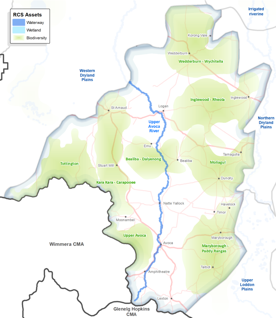
The area spans the upper Loddon, Avoca and Avon Richardson catchments, which are vulnerable to dry conditions under climate change. The upper Loddon catchment in this area is within a declared special water supply catchment area.
Mostly within the Goldfields bioregion, this area includes Box Ironbark Forests and Woodlands, and has a relatively high proportion of remnant native vegetation, protected in conservation reserves including Kara Kara National Park and others that are jointly managed by Dja Dja Wurrung and Parks Victoria. While these forests and woodlands support many unique and rare species they are generally in poor condition as a result of previous logging, gold mining etc.
There is a high proportion of rural residential properties in the eastern half of the area between Talbot and Wedderburn. These smaller properties are a legacy of the gold mining era, but when the gold ran out, the blocks were too small to make a living from farming. Unlike the rural residential areas to the southeast, this area is not well connected to regional centres for employment.
Agricultural land use is predominantly dryland grazing, except for the plains around Natte Yallock where dryland cropping is common, and the Pyrenees wine region around Avoca. Erosion is an issue on the steeper slopes in the southern parts of this area.
A snapshot
| Aspect | Description |
| Key partners | Traditional Owners: Barengi Gadjin Land Council, Dja Dja Wurrung DELWP, Parks Victoria, Trust for Nature, Bush Heritage and Agriculture Victoria Local Government: Pyrenees, Central Goldfields, Northern Grampians and Loddon shires. Landcare Networks: Buloke Northern Grampians, Upper Loddon and Avoca, Loddon Plains. Water corporations: Goulburn Murray Water (rural), GMW (urban and rural), Coliban Water (urban), Central Highlands Water (urban). |
| Socio-economic | Area between Talbot and Wedderburn is the most extensive area of socio-economic disadvantage in Victoria (aligns with rural residential area). |
| Bioregion | Goldfields, Victorian Volcanic Plain |
| Native vegetation cover | Relatively high proportion of native vegetation. The Land Cover Time Series data for the period 2015-19 showed that native vegetation of some type, covered 58% of this area. |
| Rural residential or agricultural | >80% of rural households between Talbot and Wedderburn are estimated to be rural residential (non-farmers), less so in the western part around St Arnaud – as interpreted from of ABS data. |
| Agricultural land use | Dryland cropping on the Natte Yallock Plains and dryland grazing elsewhere. The Land Cover Time Series data for the period 2015-19 showed that dryland cropping covered 28% of this area, and pasture (not native) covered 12% of this area. |
| Soil and land use overview | This is an area of considerable contrast. On the one hand there are the rich soils formed on the alluvial floodplains in the upper Avoca River valley exemplified by the Natte Yallock basin. On the other is the rugged hill country comprising repeated high and low relief granitic lands and their attendant steep metamorphic ridges typical of the land between St Arnaud and Inglewood. The former is highly productive and well-suited to productive cropping and grazing industries. Fertility in the latter is most often restricted to the alluvium and colluvium found in the valleys and foot-slopes of the granitic lands. Both units are prone to severe water erosion and gully erosion is commonplace in some areas. The intensely weathered low relief granitic terrain is highly prone to both tunnel and gully erosion, cf. Murphy’s Creek granite. |
Current and future challenges
The Western Goldfields faces challenges including:
- The most extensive area of social disadvantage in rural Victoria which is associated with rural residential properties between Talbot and Wedderburn.
- Rural residential landholders don’t always have the knowledge, skills or resources to manage their land in a way that supports environmental values. Capacity building and support are needed.
- Many smaller properties and landholders, means that engaging can be time consuming and this can be a barrier for some programs.
- Vacant rural residential blocks within Central Goldfields and Pyrenees shires (planning legacy issue), can’t be developed or aggregated for farming because they are marginal agricultural land.
- Increasing temperatures and more heatwaves predicted under climate change, could have adverse impacts on community wellbeing.
- Climate change will affect flows in the unregulated Upper Avoca River – putting significant pressure on the aquatic ecosystems.
- Box Ironbark Forests and Woodlands of this area are in poor condition, vulnerable to further drying under climate change, and require active restoration to halt further decline (refer Biodiversity theme page for more on this).
- Erosion is already an issue in the steeper terrain (Lexton and Amphitheatre areas), which may be exacerbated due to increasing incidence/intensity of floods/drought under climate change
- Increasing threat of wildfire due to hotter drier conditions predicted with climate change.
Opportunities
Key opportunities for the Western Goldfields include:
- This area has large areas of remnant vegetation, with non-government organizations (Trust for Nature and Bush Heritage) invested and community-based NRM groups established – presenting opportunities for restoration and improved connectivity.
- Where there is marginal agricultural land and vacant rural residential blocks that can’t be developed, there may be opportunities to manage for conservation.
- Includes some areas with relatively high carbon sequestration potential as compared to the rest of the region which presents opportunities to leverage the carbon market for revegetation projects.
Priority directions
Plans of relevance to this area include:
The Dja Dja Wurrung RSA involved transfer of six of the region’s parks to Aboriginal Title – four of which are within the Western Goldfields (listed below). In collaboration with partner organisations the Dhelkunya Dja Land Management Board developed a Joint Management Plan (JMP) for:
- Kara Kara National Park
- Kooyoora State Park
- Paddys Ranges State Park
- Wehla Nature Conservation Reserve
Bush Heritage Australia and Trust for Nature jointly developed the Kara Kara-Wedderburn Landscape Plan 2016–20 (soon to be renewed) to enable the local community to work together to reverse the decline of threatened species and to reconnect natural ecosystems of the Kara Kara-Wedderburn region. This Plan encompasses six priority biodiversity assets in this area.
Priority directions of relevance to the Western Goldfields include:
- Continue to build partnerships with Traditional Owners towards self-determined participation and leadership in water and biodiversity planning and management.
- Deliver community-based participatory programs that build the capacity of land managers/holders, to improve land health.
- Continue to increase the skills and capacity of partners, service providers and landholders to improve soil health.
- Work together to develop place-based climate change resources for landholders and managers, to inform adaptation.
- Build community awareness and capacity around the management of water resources and waterways, in the context of climate change.
- Deliver targeted programs to build the capacity of rural residential landholders, to protect and enhance soils, water and biodiversity values.
- Maintain and improve the quality of our remnant native vegetation and habitats, considering climate resilience, with a focus on RCS priority biodiversity assets.
- Build climate-wise connectivity by; promoting a broad strategic approach, enabling and encouraging local investment and action, leveraging incentives and market opportunities.
- Collaborate to maximise the potential of carbon market investment, to contribute to land, water and biodiversity outcomes.
- Undertake pilot projects across the region, to develop effective methods for holistic Box- Ironbark Forest and Woodland restoration, to inform and broaden this practice and increase investment in their management.
Priority directions relevant to the regional community generally, include:
- Build capacity, networks and leadership to enable community led climate solutions for land, water and biodiversity management.
- Support, improve and expand the environmental volunteering sector, including Landcare, to enable adaptation to demographic shifts, to continue their important role in NRM.
- Enable, improve and promote opportunities for people to connect with nature, in both urban and rural settings, for wellbeing, to build awareness and appreciation, and inspire action.
- Support schools and young people to participate in programs that increase their knowledge and awareness of natural resource management.
- Continue to support integrated citizen science programs that engage community and provide useful targeted data to inform water, land, climate and biodiversity programs.